
Remote Sensing
The physical layer of the earth can be monitored by remote sensing. The satellite that orbits around the Earth captures the image of the Earth. New technology based on drones or unmanned aerial vehicles also aids in the collection of topographic pictures. These image sources can feed a large information about an area. The depth, moisture, habitat, livestock, crop, and other information can be extracted from the image sources where the places are impassible. Data analysis is widely used in many fields yielding a lot of useful applications such as classification and prediction. The data analysis can also serve the remote sensing domain in the study of changes in climate, weather prediction, topographic analysis, habitat analysis, etc.
Revolutionizing Remote Sensing
Indian Space Research Organisation has a large number of remote-sensing satellites. The images can be sent to the Earth station and the machine learning analysis can be performed on the earth station. Few satellites can be operated as onboard operational satellite that performs all analysis in the space station thus reducing the time. In January 2022, NASA launched ION-SCV 004 satellite which has a trained machine-learning program for remote sensing. The model named RaVAEn identifies the changes in the cloud. This model has the capability of training 1300 images in one-and-a-half seconds. It detects the presence of clouds in a 4.8 square km area.
Researchers are planning to develop advanced machine-learning models to analyze flooding, deforestation, and natural calamities. More studies are planned to train complex data analysis such as identification of harmful gas leakage.
The researchers studied the corn field by topographic satellite images in the United States. The work focused on the prediction of the corn yield by machine learning models. Various models are used such as extremely randomized trees, gradient boosting machines, XGBoost algorithms, and stacked ensemble models. The model performance results show that the topographic images taken at the time of the flowering growth stage give better accuracy.
ML on Remote Sensing
Other studies using ML techniques on remote sensing include the classification between forests, urban, rural, water bodies, and agricultural areas. The ML models can also be useful in traffic monitoring by sensing satellite or drone images. Studies on the identification of flooded areas and detection of changes in water flow can help in flood management in the future. More precise research on satellite-based aerosol measuring can monitor and predict air quality. Illegal land use can also be identified by the ML-aided remote sensing technique.
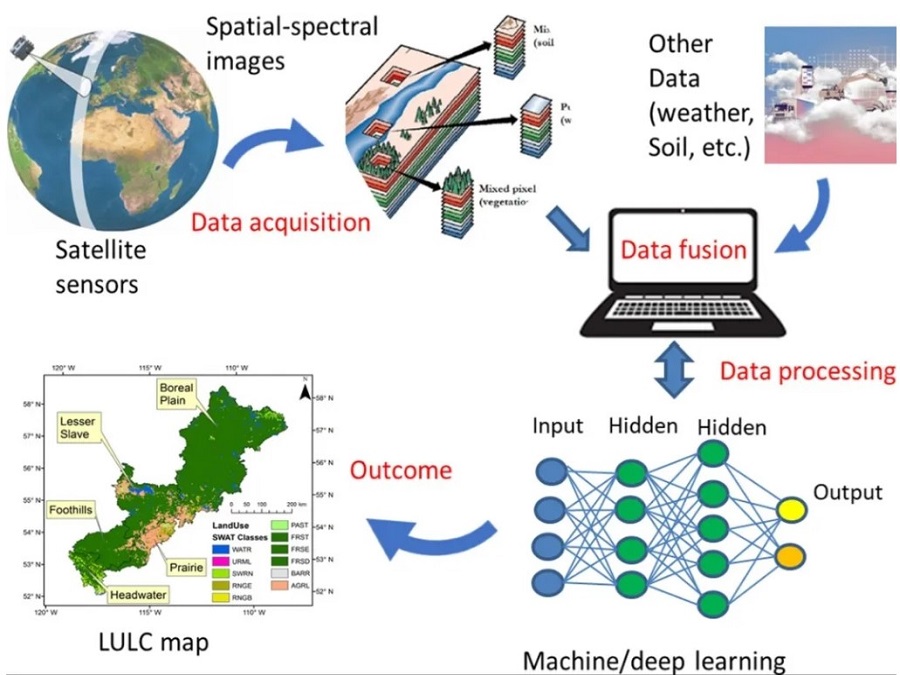
Unmanned Aerial Systems are already used in digital agriculture such as tillage, planting, spraying, and harvesting. The Genome-Wide Association studies help in genotype selection tools based on ML models. A specific research study estimates surface soil moisture by data fusion and deep learning techniques on multi-sensor satellite images. The training, validation, and testing images are taken in the ratio of 60:10:30. Various machine learning algorithms are used to compare the performance of different machine learning algorithms such as Generalized Regression Neural Network, Radial Basis Network, Exact RBN, Gaussian Process Regression, Support Vector Regression, Random Forest, Boosting Ensemble Learning, Recurrent Neural Network, Binary Decision Tree and Automated Machine Learning. The performance for all the scenarios shows a steady performance.
Very Recent research finds the application of AI in the prediction of Spatiotemporal Distribution of Dengue Fever Outbreaks by using remote sensing data. It’s a novel use case for the identification of epidemic diseases based on satellite images. Although ML is already useful in various applications specific to disease identification on individuals, a region-oriented study can be more advantageous to predict dangerous outbreaks like dengue by ML-aided remote sensing technology. One recent research identifying dengue and other zoonotic diseases due to variations in climate by ML-aided remote sensing can enable to establishment of preventive measures to avoid such outbreaks.
Conclusion
A very popular quote “Prevention is better than cure” can be remembered at this moment. Dangerous diseases like malaria, dengue, and other mosquito-borne diseases affect many humans throughout the world. It could be beneficial in predicting the location of a dengue outbreak and can avoid the spread of the disease. Professor Sumiko Anno from Sophia University, Japan combined remote sensing with AI for the prediction of dengue fever outbreak in the study of spatiotemporal distribution. The team collected the climate data for a period of 18 years including rainfall, sea-surface temperature, and shortwave radiation, place of residence of all reported dengue cases. Based on the collected data the training model is generated. A CNN model performed the image segmentation and feature extraction. However, the model did not perform well. The predicted region did not match the original data. However, the predicted location is quite close to the actual location of outbreaks. Hence the researchers used a spatiotemporal model in prediction.
Even though the results of the research is of low accuracy, it provides a brainstorming approach toward the identification of outbreak of diseases by remote sensing data.
A wise saying that gives the importance of the study of land by remote sensing is “Conservation is a state of harmony between humans and land”
Source links:
- https://www.mdpi.com/2072-4292/14/22/5760
- https://post.parliament.uk/research-briefings/post-pn-0628/Deep learning and data fusion to estimate surface soil moisture from multi-sensor satellite images | Scientific Reports (nature.com)
- https://www.earthdata.nasa.gov/learn/backgrounders/remote-sensing
- Remote Sensing | Free Full-Text | Training Machine Learning Algorithms Using Remote Sensing and Topographic Indices for Corn Yield Prediction (mdpi.com)
- Machine learning use case in remote sensing | by Balajiwork | Jul, 2023 | Medium
- https://www.ibm.com/topics/machine-learning