
Dashing through the stars
Do you have concerns about our current environmental conditions?
How can technology help? Through the application of remote sensing technology, we can anticipate the transformations occurring due to both human-induced and natural alterations on Earth. By utilizing sensors mounted on satellites or aircraft, we can sensitively forecast these changes and take steps to minimize their effects, thus preparing ourselves for what lies ahead.
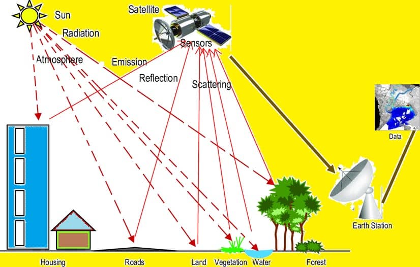
Is remote sensing purely a science, a tool, an art, or a technique? In truth, it’s a seamless fusion of all these elements. Can you imagine a sizable camera capturing images of Earth? Indeed, that’s the essence of remote sensing. Refer to the image below to understand the process behind remote sensing.
How it works?
Remote sensing begins with an energy source that illuminates the target, often provided by the Sun or an onboard EMR source. This energy interacts with the atmosphere, and a sensor is needed to collect and record the electromagnetic radiation emitted or scattered by the target.
Energy transmitted to the target interacts based on their properties, involving reflection and emission processes. The sensor records the scattered energy, using photographic or non-photographic sensors, and transmits data to processing sections. In data processing, the received information is transformed into images, which are then interpreted and analyzed visually or digitally using GIS or Remote Sensing software.
Next level of Exploration
What matters here is the complexity of analyzing data, it will be helpful if the prior analysis is done with the collected data before sending the reports to users from earth-based stations. This happened with the machine learning model RaVAEn to identify the changes in the cloud cover, as a stepping stone now the model is trained with 128 compressed large-size files. To speed up the process between data acquisition and processing machine learning plays a major role. It happened with the ION-SCV 004 satellite late in 2022.
In just one and a half sec RaVAEn can train 1300 images and 1 in 10 sec it can able to find whether the cloud is present or not. Just imagine 450 football grounds, It can be encoded of an area of 4.8 x 4.8 km area.
Many trials are happening in streamlining the models with RS and ML, such as Crop yield prediction models, crop disease detection, Air pollutants, and health effects, ML for irrigation scheduling, earthquake studies, Air quality models, and Soil studies.
Application of ML in remote sensing goes on in the future such as Identification of changes in environmental attributes such as Air, Water, and Soil. It’s essential to model the system for change detection with complex data.
Indian Remote sensing satellites
India’s remote sensing satellites include the IRS series for diverse applications. The RESOURCESAT series focuses on resource monitoring, while the CARTOSAT series offers high-resolution imaging for mapping and planning. RISAT satellites utilize synthetic aperture radar for all-weather observation. OceanSat satellites monitor ocean parameters, contributing to oceanographic studies. HysIS, launched in 2018, captures hyperspectral data for agriculture and environmental monitoring. Some GSAT communication satellites also serve meteorological and Earth observation functions. India continues to advance its remote sensing capabilities with ongoing satellite developments.
Integration of Remote sensing and Machine learning
Within the realm of impact evaluations, the utilization of geospatial data emerges as a pivotal facet, enabling the comprehensive measurement of intervention outcomes. This analytical approach is increasingly incorporating the synergy of Artificial Intelligence (AI) and machine learning (ML) techniques, establishing them as integral components of impact assessment methodologies. Particularly noteworthy is their role in crafting nuanced classifications of data, exemplified by the categorization of land cover and land use through the analysis of satellite imagery.
Moreover, the synergy between remote sensing data derived from satellite observations and traditional socio-economic data is a noteworthy aspect. In this integrated approach, remote sensing data serves as a potent tool for a segment of the impact evaluation process. Subsequently, the socio-economic data, collected through conventional methods, steps in to either complement or validate the findings derived from geospatial analyses.
Conclusion
The amalgamation of these diverse data sources not only bolsters the comprehensiveness of impact evaluations but also contributes to the robustness and reliability of the overall assessment. By harnessing the strengths of AI, ML, and traditional data collection methods, practitioners in the field of impact evaluations can navigate a more comprehensive and insightful terrain, thereby fostering a more informed understanding of intervention outcomes.
Source